THE GEOGRAPHY OF CARDIFF
A low laying County

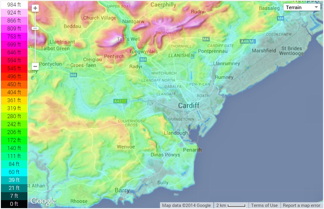
© Google Maps
Development

Cardiff is the Capital City and County of Wales. It is located on the southern coast of the country, bordering the country of England to the east, in the United Kingdom of Great Britain and Northern Ireland.
According the national census data, the population of Cardiff has risen from 305,400 in 2001 [REF], to 346,000 in 2011 [REF], to 362,400 in 2021 [REF]
The city developed in the mainly low lying and reclaimed marshland on top of a Triassic landscape, on the coastal region of southern Wales.
Although Cardiff's exporting capabilities were not realised until the 19th century, when the Butes built their first dock, it has nevertheless been a strategically important location for thousands of years.
It has a maritime climate, with temperatures ranging from up to 30 degrees in the summer, to minus 10 in the winter.
Cardiff is bordered by the County Borough of Caerphilly to the north, the Vale of Glamorgan to the west, and the City of Newport to the east.
It is also divided by three rivers; the Ely in the west, the Taff through the centre, and the Rhymney to the east. Both the Taff and Ely flow into Cardiff Bay, creating an artificial lake.
The flow of the lake is controlled through the barrage at the most southerly point of the city, which then enters the Severn Estuary (on which Cardiff's Coal exporting ports were based).
Flooding
The estuary joins the Bristol Channel some five miles out to sea, which has the second highest tidal range in the world.[REF] The treacherous waters have been responsible for many devastating floods over the centuries.
One of the worst recorded was the Great Flood of 1607. Geography, topography, high tides and a deep low-pressure storm surge all conspired to wreak havoc across South Wales, Gloucestershire and the Severn Valley.
Cardiff’s moors were swamped as the waters over-topped the ancient sea-banks and came as far inland as Canton and Adamsdown. The River Taff burst its banks and undercut the foundations of 11th century St Mary’s Church, irrevocably damaging it.[REF]
Cycle Friendly
Source: topographic-map.com ⁄ © Google Maps
The city centre and inner districts sit in a 'bowl' - the flat landscape and many bike lanes making travel to the hilly suburbs a little less tiresome. The city is particularly blessed with lots of green open spaces which are used for sporting activities, and tree lined trails which snake through many of the estates.
The general lack of rolling hills, with the exception of the outlying suburbs, make cycling particularly appealing to all ages; very little effort is required to travel across the city. As a result, cycling has become more popular, being an eco-friendly and time-conserving method of getting about.
This boost in the uptake of sustainable transport, coupled with the pedestrinisation of the main thoroughfares in the centre of the city, has dramatically improved air quality and slowed the degradation of the historic buildings.
Wards and Suburbs
The City itself is made up of over 20 main suburbs (wards) which contain some of the largest housing estates in Europe.[PDF]
Contained within these suburbs are numerous villages and sub-wards, which are explored in greater detail, further on in the site.
Visiting Cardiff
The city has excellent transport links including Cardiff International Airport, the First Great Western railway, and the M4 motorway - all of which seamlessly connect Cardiff with London.
The coast is a short drive from anywhere in city, and the popular seaside towns of Barry and Penarth are just a few miles west of the county border.
It's a great place to visit, and the ideal base from which to explore the coast, culture and heritage of Wales, southern Britain and neighbouring Europe.
PAGE UPDATE HISTORY
02 April 2024 (Coding updates)
20 October 2023 (Coding and content updates)
30 December 2014 (Coding updates)
December 2005 (Page Created)