THE HISTORY OF CARDIFF'S SUBURBS
THE CIVIC CENTRE
Incorporating Temperance Town and southern Cathays

CONTENTS
Tap or click to open / close
The Silures
The Roman Invasion of South Wales
Occupation, and construction of the Castrum
Withdrawal of the Empire
Annales Cambriae
Viking Settlement
The King of Wales - Gruffudd ap Llywelyn
Norman Invasion
Robert Fitz Hamon and the First Castle at Cardiff
Gilbert de Clare and the Welsh Uprising
Owain Glyndŵr
Cardiff in the Middle Ages
The Butes - Forefathers of Cardiff
Temperance Town
City Status
The Two World Wars, and the Depression
County of South Glamorgan
City and County of Cardiff
The Recession and Recovery
The Silures
For hundreds of years, and long before the Roman Empire invaded Britain, South Wales was controlled by a Celtic tribe called the Silures (Latin: 'the people of the rocks', reflecting the mountainous region in which they lived).
Tacitus, a Roman historian in the late 1st century, described the Silures as swarthy and curly-haired with possible Spanish ancestry.
This powerful and warlike race had dominated what is now Glamorgan, Brecon and Monmouthshire since at least 650 B.C.
There are very few remains of the Silure occupation in South Wales, mainly due to the tribe's pastoral lifestyle. Instead of living in stone-built dwellings, they would have most likely lived in temporary wooden structures and lived mainly off the land. No pottery or iron workings from this time were ever discovered.
The Roman Invasion of South Wales

Original map created by Andrei Nacu.
When the Romans invaded Britain in A.D. 43, almost all of the native tribes in the country succumbed to the technologically superior troops.
By the year A.D. 48, North Wales had fallen to the Romans who were steadily marching on Brecon and southwards.
Numerous attempts were made by the Romans to conquer South Wales, and at one point they were partially successful. Under the command of General Aulus Didius Gallus, Cardiff was finally taken long enough to construct a wooden fort on the eastern bank of the River Taff.
It is thought that the fort takes its name from Aulus Didius and this may be the origin of Cardiff's name (Caer Didius - Fort of Didius = Caerdydd in modern Welsh). There have been numerous corruptions of the name over the centuries and it could have been that the fort was named after the Taff (Caertaff - The Fort on the Taff).
However; even with a Roman stronghold in Cardiff, the Silures continued to fight them off using their knowledge of the land, and warrior prowess, to defeat the invaders. The fort was abandoned and the lands of South Wales remained unconquered for nearly 30 years.
It was only a matter of time before the Romans gathered enough of their forces to make a serious attempt at overwhelming the tribe once and for all.
Growing weary of the Silures' continued opposition, the Roman Emperor Vespasian instructed Praetor and Engineer, Sextus Julius Frontinus, to take a huge army to Britain and conquer the rest of Wales.
The Via Julia Maritima, a paved Roman road leading from Caerleon to Neath, was being constructed. Cardiff was at the half way point on this route (which is now Newport Road) and it was imperative that the Romans controlled the crossing at the River Taff. In A.D. 74, Frontinus had taken Monmouthshire, and was readying his troops for a final assault on Cardiff.
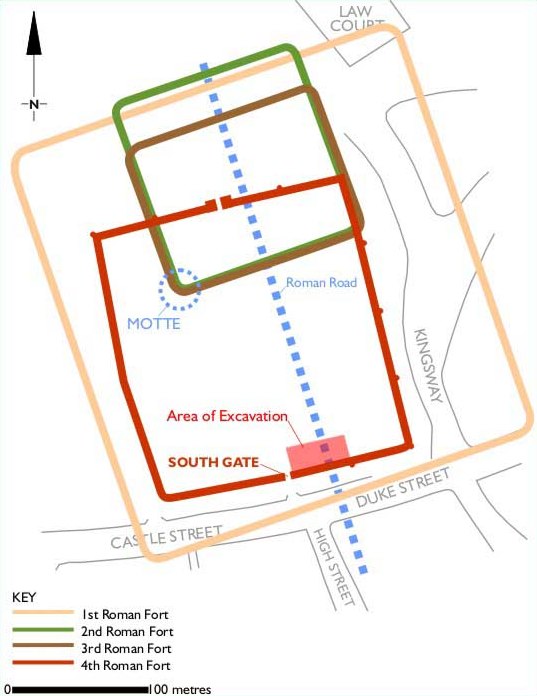
Occupation, and construction of the Castrum
With a new camp in Caerleon protecting the border, the army marched on to South Wales and finally took it as their own in A.D, 75.
It is not entirely clear why the Silures eventually ended their attacks on the invading forces, but records indicate that the Romans attributed a great deal of respect to the tribe, who refused to be enslaved or Romanised like the rest of the tribes in Britain at the time.
With the Silures finally subdued, the Romans used the original nucleus of the wooden walls and buildings to build a more substantial base. A ditch and rampart was constructed, and it is likely that a Barracks was also built. Sometime between A.D. 100 and 260 the third and smallest fort had been built.
Small archaeological finds dating back to around A.D. 260-400 indicate a small settlement was forming within the walls, with evidence of smelting and tile making.
By the mid 350's, the Romans were now dealing with attacks from the Saxons (from Northern Germany), the Picts (from Scotland) and the Irish, so a bigger and stronger fortress was required.
In a final attempt to strengthen their position and regain their military superiority, the Romans rebuilt it in stone, to replace the aging wooden castrum.
The almost square shaped walls are 3 meters thick at the base, rising to about 5 meters high and remains of these 4th century walls are still visible to this day, in the basement of the current castle. The final Roman fortification at Cardiff would prove to be pointless however.
Withdrawal of the Empire
Original source: Peter Webster (The Cardiff Story, p24, Dennis Morgan)
Unlike the rest of Wales and England, the Romans never really settled in Glamorgan. Most of the Roman remains in Cardiff are military in nature and it is thought that the difficult geography and poor climate contributed to the lack of farming evidence.
Fifty years after the construction of the stone fort at Cardiff, the Romans suddenly departed, as swiftly as they had first came. Rome itself was under attack from Germanic barbarian tribes in the early 5th century and its defenses were crumbling, causing disunity amongst Roman citizens.
A General stationed in Britain, Flavius Claudius Constantinus (Constantine III), took the initiative to return to Rome in 407 and declare himself Emperor. In doing so, he took with him all the troops in Britain back to the homeland. It was Constantine's intention to bring reinforcements which would boost morale and unity, thus fending off the barbarian attacks and save the city.
The plan did not work however; Constantine was unable to prevent the Sacking of Rome in 410. He abdicated and was executed a year later.
By 450, Britain was no longer part of the Empire and all that was left to protect Cardiff, and indeed the rest of Wales from the invading tribes were the local militia (part-time soldiers drawn from local communities).
Annales Cambriae
Unfortunately, there is little known about Cardiff from A.D. 410. The first written evidence of Cardiff's existence was made in 455 and can be found in the Annales Cambriae (The Welsh Annals). The Annals were comprised of four manuscripts, and compiled into a single document sometime in the 10th century.
The Annals recorded events taking place across Wales, as well as many parts of Britain. Cardiff is not mentioned again, so it seems that the camp quickly deteriorated and was forgotten about.
These documents are also the source of the legend of King Arthur, who led the defense of Britain against the Saxons in the 6th century. For the next 400 years it seems that the fort and the settlement were deserted. Wales was split into regions ruled by the emerging Welsh Kings, and the region in which Cardiff lies comes to be known as Morgannwg .
Viking Settlement
In A.D. 850 the Vikings, who had been attacking the coastline of Britain for centuries, made a significant raid on Cardiff.
The remains of the fort, and a possible Roman camp at the bottom of Rumney Hill, may well have been the reason that the Vikings set up small settlements on the banks of the Taff and Rhymney.
The remaining enclosures would have afforded the Vikings with some protection, and as a result, the beginnings of Cardiff's long tradition as an important port were set in motion. Some places in Cardiff still retain their Viking names to this day.
Lamby (in Rumney) was a Viking settlement which traded along the River Rhymney, whilst Dumballs Road was the site for another camp.
Womanby Street is the oldest street in the city; its route has not changed in over 1,200 years. Starting at Castle Street it leads down from the castle, to the junction with Quay Street, where an ancient dock used to exist alongside the River Taff.
The King of Wales - Gruffudd ap Llywelyn
By the mid 11th century, the Welsh had a king, Gruffudd ap Llywelyn, who was probably the most successful ruler of medieval Wales.
He made many enemies in Wales on his way to power, and made a point of attacking England repeatedly during his reign.
After the death of a significant ally, his stronghold at Rhuddlan was attacked on the orders of Harold Godwinson, the last Anglo-Saxon King of England. Llywelyn fled to the mountains at Snowdonia, but was eventually murdered by his own men in 1063.
King Harold came to an agreement with the Lords of Wales, to divide the Country into separate Kingdoms, rather than one whole. This decision would not bear well for Wales' ability to repel the forthcoming French invaders, the Normans.

Source: Unknown
The Norman Invasion
King Harold may have avoided conflict with Wales, but still had to deal with impending invasions from Norway and Normandy. In September 1066, Harold fought off the Norwegian invasion at the Battle of Stamford Bridge. A month later The Duke of Normandy, William the Conqueror invaded England, and killed Harold at the Battle of Hastings.
William took the title King William I of England and initially had no particular interest in the Kingdom of Wales, so made no attempt to take the Country.
Before his death in 1087, he gave large swathes of English land to his most loyal supporters, and made them Lords. However; the following decade saw increasing attacks from the Welsh, who had joined forces with English rebels.
Robert FitzHamon and the First Castle at Cardiff
Lord of Gloucestershire, Robert FitzHamon, attacked South Wales in around 1091. He slew Iestyn ap Gwrgant, the ruler of the Morgannwg and very quickly established his leadership in the Kingdom.
He ordered the construction of a motte (mound) and wooden bailey (keep) in the middle of the dilapidated Roman castrum in Cardiff.
Once FitzHamon had control of Morgannwg, he allowed the remaining Welsh Lords to manage the surrounding mountainous region. By the 1120's, FitzHamon had died in battle and the estate passed to his daughter and her husband, Robert the Consul.
A wooden palisade was erected to protect the fledging town and the predominantly English settlers, who were living in the shadow of the bailey. During the next 80 years the keep was rebuilt in stone and the first Mayor of Cardiff was sworn in. St. Mary's and St. John's Churches were constructed during this time to fulfill the religious needs of what was now a thriving borough, which by 1324 was now able to hold markets and fairs due to being granted its first Royal Charter.
Two monasteries were built in around 1270 - Greyfriars to the east of the Castle (the restored ruins of which lie in Bute Park), while to the west lay the Blackfriars.
Gilbert de Clare and the Welsh Uprising
The 13th and 14th centuries saw the Welsh Lords rising up again against the Normans and the English. The Kingdom of Morgannwg were attacked repeatedly by the Welsh.
The castle had been badly damaged between these attacks and efforts to capture it, so Gilbert de Clare removed the greatest threat to his estates in 1266, by capturing and exiling the Lord of Senghenydd (Gruffydd ap Rhys) to Ireland.
With ap Rhys out of the way, Gilbert de Clare was free to use his extensive resources to construct the imposing Caerphilly Castle, and the original Castell Coch in Tongwynlais, to protect the northern borders of his land.
He reconstructed the keep in Cardiff and built the Black Tower, in addition to re-building the town wall in stone. Records indicate that Greyfriars and Blackfriars Monasteries were constructed around this time. The de Clare's held Cardiff until the death of the last male in the family line in 1314, and soon after the estate passed into the Despenser family.
Two years later Llywelyn Bren (Llywelyn ap Gruffudd ap Rhys) the son of Gruffydd, saw the passing of the estate to the Despensers as an opportunity to retake Cardiff. Bren stirred up revolt amongst the English Lords and attacked the castle. He was captured, imprisoned, and killed as a traitor in 1318. The Despenser family held Cardiff until its fall in the early 15th century.
Owain Glyndŵr
The last native Prince of Wales, Owain Glyndŵr (c. 1349-1416), was fighting for Welsh independence by the beginning of the 1400's. Fed up with English-Norman rule for the last century, the people of Wales were coming together for the last time in the country's history to fight the armies of Henry IV.
In 1404, Glyndŵr made significant attacks on South Wales. He attacked Cardiff with a ferocity that it had not seen before or since. He almost completely destroyed the Norman castle and burnt the entire borough to the ground - only the original castle foundations and the shell of the keep survive to this day.
Henry IV responded with more and more troops, blocking supply routes and imposing draconian legislation. In 1409 Glyndŵr's family were captured by the King. Owain himself evaded capture but little is known about his eventual demise.
Cardiff in the Middle Ages
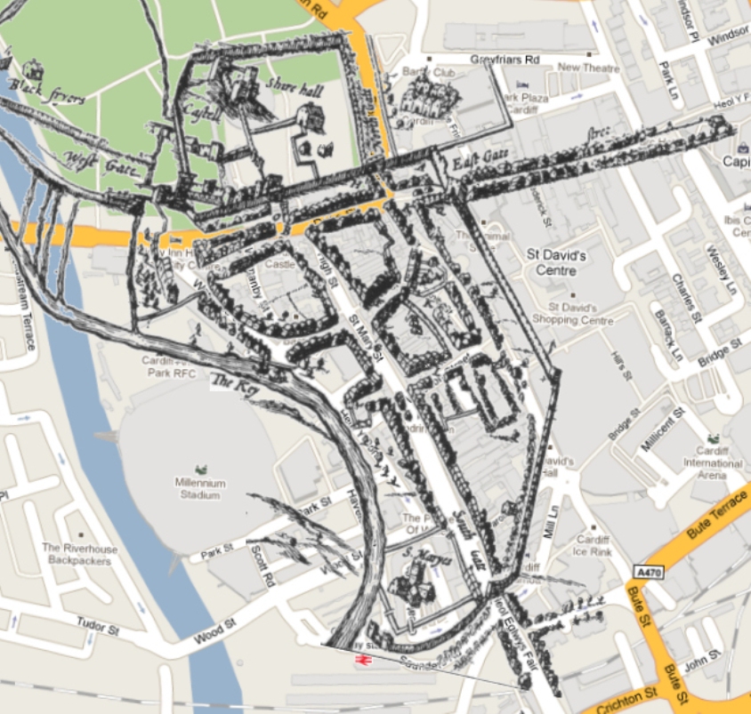
Source: Google/Matthew Witty
By 1414, the Beauchamp family had inherited Cardiff from the Despenser family through marriage. With the Welsh finally subdued after over 300 years of conflict with the Normans and English rule, peace finally came to Cardiff and Morgannwg.
The Beauchamps ordered the construction of the West Wing lodgings at Cardiff Castle, and the Octagon Tower overlooking the West Gate and River Taff.
The royalist Neville family acquired Cardiff in 1445 through marriage, and the estate stayed in the family for the next 75 years.
During this time, the manors around the castle very slowly began to develop, with farms working the ancient lands in Roath, Riverside and Cathays.
In the 1530s Henry VIII had dissolved the monasteries and by the early 16th century, the Blackfriars buildings was in ruins.
In 1550, King Edward VI granted Morgannwg, Cardiff (the county town of the new shire) and most of it's manors to the 1st Earl of Pembroke, Sir William Herbert; who was head of one of the most powerful families in England.
The Herberts restored the castle in 1574 and converted the remaining Greyfriars monastery into a mansion. Another extensive era of peace beckoned and the borough continued to grow.
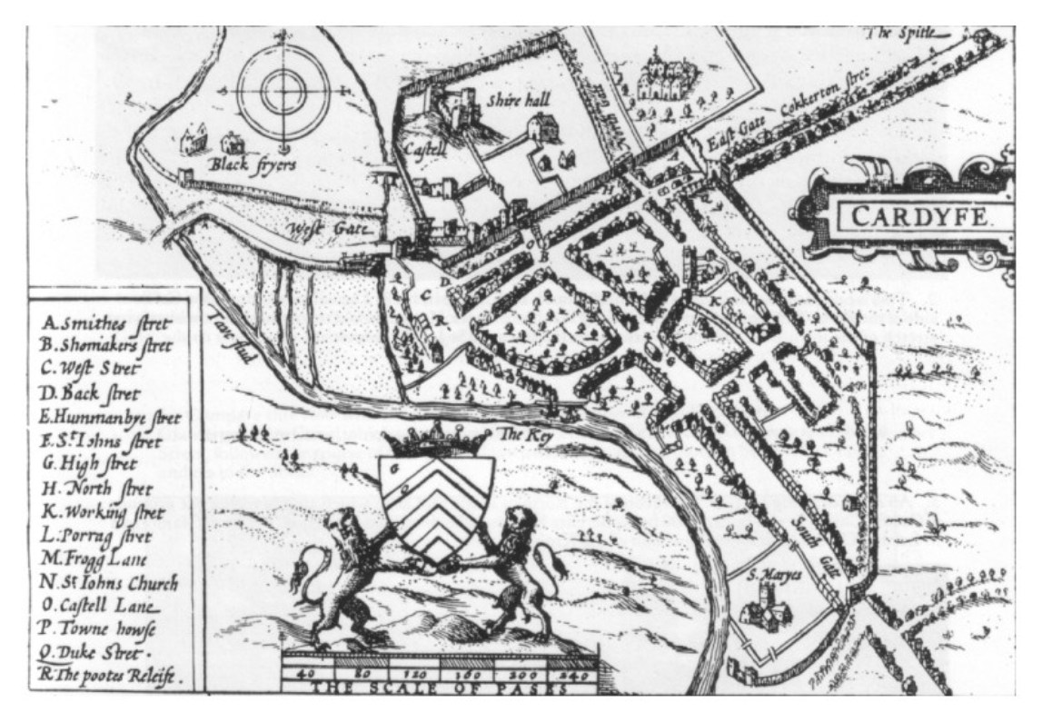
In 1607, St. Mary's Church was badly damaged by a flooded River Taff. However; the church stood long enough to be recorded on the first map of the town, produced in 1610 by cartographer and historian John Speed.
In 1642, the Herberts stood alongside the King during the Civil War between the Royalists and the Parliamentarians and the castle was attacked in 1645.
Minimal damage was caused however, and Cardiff escaped the pounding that many other Welsh provinces had taken, with the exception of the Battle of St. Fagans in 1648.
The Herberts continued to pass their estate down the family line until 1674. Phillip Herbert left the Castle to his daughter Charlotte, who married into the Windsor family.
The Butes - Forefathers of Cardiff
By the 1740's, Cardiff had its first Town Hall (Guildhall) in High Street and a market. As more merchants came to trade in the town, including those who dealt in coal, St. Mary Street and Westgate began to see increased traffic.
Glamorganshire and Cardiff passed into the hands of the Bute family, through the marriage of John Stuart, a Lord and 4th Earl of Bute to the grand daughter of Charlotte Windsor in 1766 and became the first Marquess of Bute. John's eldest son, Lord John Crichton-Stuart Bute, was bequethed the estate in 1794 upon his father's passing.
Hedging the family fortune on one of the biggest gambles in history, Crichton-Stuart built the first docks in Cardiff in 1839.
His intention to control the export of Coal from the Welsh Valleys soon led to Cardiff being transformed from an undeveloped sleepy little town into the biggest and most prosperous coal port in the world.
The second Marquess' son continued his father's work armed with the riches earned from the port. The Third Marquess, Lord John Patrick Crichton-Stuart Bute, met English architect William Burges in 1865, thus starting a collaboration between the men that would provide Cardiff with some of its finest buildings.
With the Butes funding and Burgeses architecturial skills, the Castle was substantionally renovated. The Clock Tower was rebuilt and many Gothic inspired rooms were created, including the Marquess' bedroom and smoking room. Burges also constructed Park House on Park Place for Lord Bute's chief engineer and Castell Coch in Tongwynlais.
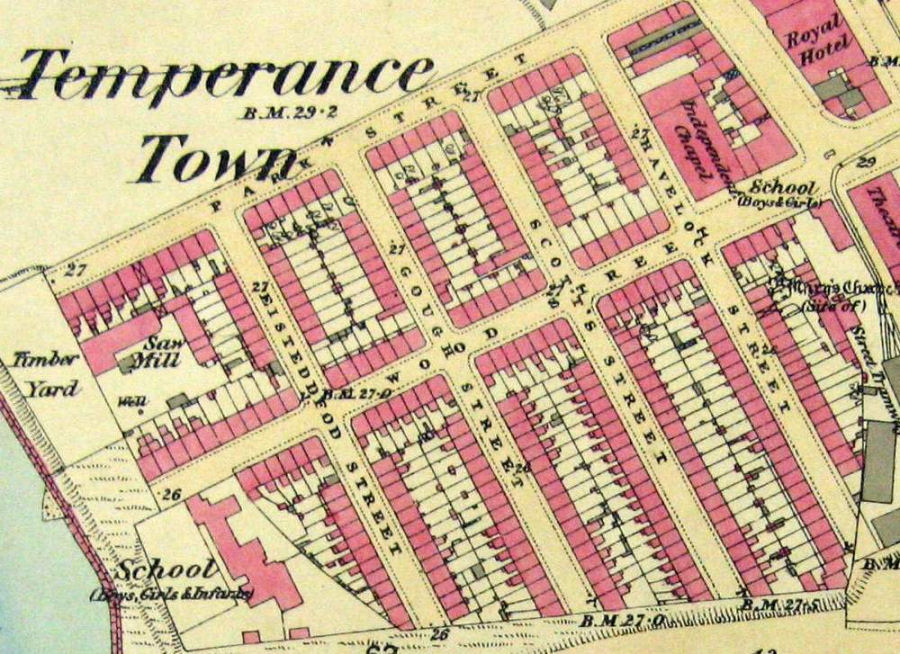
Image courtesy of Stephen Fisk
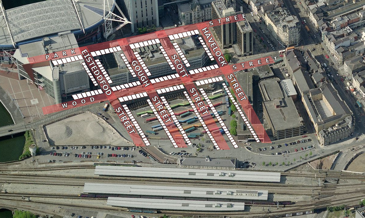
Eisteddfod Street was replaced by Scott Street, then Gough Street and Scott Street were demolished to make way for St. David's House, the Terminus Buildings.
The northern half of Havelock Street is still in use today.
Source: Google/Matthew Witty
Temperance Town
Isambard Kingdom Brunel, a brilliant English Civil Engineer, was appointed by the South Wales railway to build a connecting line from Cardiff to Swansea.
Initially, problems arose with the proposed location of the station. The River Taff at the time was much wider, with a more meandering route.
The river had been the cause of major flooding throughout the Town's history, including the destruction of St. Mary's church.
Brunel decided to change the course of the river, and reclaim a vast section of land. The work was completed by 1859 and soon after Cardiff General had been built.
The remainder of the reclaimed land north of the new Railway Station, now an undeveloped mud pit, was now owned by Colonel Edward Wood. He leased the land to Jacob Mathews, who was given permission to use the pit as a rubbish tip in the 1860s.
During the same decade Colonel Wood (a teetotaller) authorised the building of a small housing estate, with the condition that no traders of alcohol be allowed to operate in the district. It is likely that this is how Temperance Town got its name.
Cardiff Cricket & Rugby Club had its first stands constructed on land donated by Lord Bute, with Rugby matches taking place as early as 1881.
By 1890 a church, schools and Temperance Hall had all been constructed, while Wood Street was attracting many businesses.
The Hall was converted into a Congregational church in the early 20th century, and demolished to make way for South Gate House.
City Status
Cheifly due to the Bute family's wise investments, Cardiff had now become a County Borough and its population was increasing dramatically.
Although Barry Docks in the nearby Vale of Glamorgan was a serious contender to Cardiff's own exporting facilities; the town had easily sealed it's status as the centre of trade and commerce in South Wales.
The construction and opening of the new Cardiff Central Market took place in 1891, on the site of the 1835 Haycock building. The small alleyway adjacent to the 'Old Arcade' public house has been used by shoppers for 175 years!
The Butes sold land in Cathays Park to the Town Council in 1898 and plans were drawn up for the construction of a new Town Hall to replace the fourth, and aging Hall in St. Mary Street.
The new Hall at Cathays Park was completed by 1904 but less than a year later, King Edward VII had granted Cardiff City status.
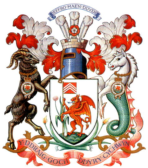
The brand new Town Hall became the City Hall, and is still used today as Cardiff County Council's administrative centre. In 1906, Cardiff was granted its very own Coat of Arms.
The streets of the City were changing quickly - horses were being replaced with electric trams, roads were widened and improved, and grand shopping arcades were opening.
Cathays Park was expanding with impressive buildings, including City Call which replaced the old Town Hall in St. Mary Street.
By 1914, the population of the town had shot up to over 150,000 residents, and the City's exports via the expansive Bute Docks was increasing dramatically.
Black gold, better known as coal, was primarily responsible for this explosion in Cardiff's wealth and poularity.
The Two World Wars, and the Depression.
Although Cardiff was left unscathed, the City entered a period of decline during the first World War. Coal exports in the docks which had recently hit record highs, were now beginning to drop off quickly.
The second World War began in 1939, and the docks were called back into use again for military activities.
This would lead to the City being bombed by German Luftwaffe between 1940 and 1944. Thankfully, historical buildings in the Civic Centre, the Castle and St. John's church were all spared.
However, Llandaff Cathedral sustained heavy damage and many civilian buildings in suburbs surrounding the City Centre were destroyed.
The poor quality housing and sanitation in Temperance Town led to it's demolition in 1937. The land was used for the buiding of the Central Bus Station in 1954.
In 1955, after a decade long campaign by residents and local government officials, Cardiff was made Capital of Wales. This new title attracted world events, such as the Commonwealth Games in 1958, for which the Empire Pool was purpose built.
The Glamorganshire Canal, which had snaked its way through the City since 1794, had by now been sold off by the Bute Family to the Cardiff Corporation. Many parts of the canal, in particular Mill Lane and Churchill Way, were covered over in 1958. It is still possible to trace its original route, from the sections where it mysteriously appears and vanishes again under the offices which now stand on its centuries old banks.
County of South Glamorgan
In 1974, the ancient County of Morgannwg was restructured and Cardiff was demoted from County Borough, to a County in the new South Glamorgan.
The Capital's economy was still experiencing instability; as newer retail businesses were settling in the City Centre in the early 80's, the industrial estates on the outskirts were shutting down and shedding jobs.
The National Stadium, Cardiff Arms Park, was opened in 1984 on the site of the Cardiff Cricket & Rugby Club. More and more shopping arcades, such as St. David's and Queen's West were opened and offered easy access to the recently pedestrianised Queen Street. Increased traffic to the city meant the need for major new link roads.
By 1988 the Ely - Grangetown link had been completed, making it possible to travel from Culverhouse Cross to the City Centre, completely bypassing all of the suburbs to the south.
City and County of Cardiff
The commercial centre of the City was continuing to expand, and the population had risen to nearly 300,000.
The local government reorganisation in 1996 allowed Cardiff to revert to its County status. The City Centre had not been given a radical overhaul since the 1970's, but the outskirts of the Capital had been flourishing quickly, as out of town retail parks starting to spring up.
In a combined effort to rejuvanate the centre, and bring trade and interest back to Cardiff's historical centre, the Empire Pool was demolished, and Millennium Stadium constructed in time for the final stages of the 1999 Rugby World Cup.
The Recession and Recovery
Cardiff continued to grow quickly during the boom years of the late 90's and early 2000's, but it wasn't until 2004 that a certain television production finally brought Cardiff into the living rooms of millions of people.
Doctor Who, and its spin-off Torchwood both started filming in the City - creating a level of interest unparrelled since the days of the Coal Merchants.
The old industrial sites were rapidly being replaced with media production companies, offices and retail centres - but something new was required to solidfy Cardiff's position as an attractive place to shop for big brands and chic fashions.
Building on the City's growing reputation and pride - a new £675 million shopping centre - St David's 2 - was constructed. The scheme provided thousands of jobs, but caused disruption in the City Centre for years, with many draders citing the construction work as detrimental to their business.
Demolition of land marks such as the Ice Rink, Central Library and Toys R Us started in 2006, but Oxford Arcade took a little longer. The arcade had been built on a boundary of the historic town wall, so archaeologists were called in to try and find remains of the wall as well as 'Cock's Tower', a medieval watchpost and dungeon until around the 16th century.
It would be unlikely that any remains would be found on such badly disturbed ground, and construction continued soon after. The global recession had firmly taken hold of Cardiff in 2008, but although many housing projects throughout the City were mothballed, the City Centre itself was a hive of activity.
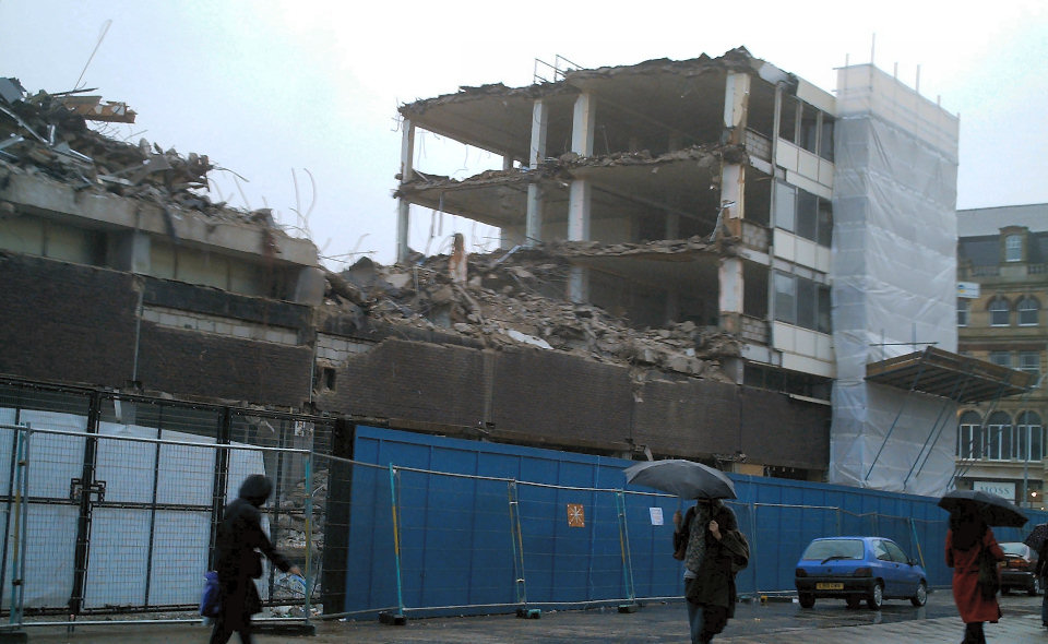
A new library was built in the Hayes, adjacent to the flagship store in the new shopping complex, John Lewis. The Central Bus Station terminus buildings were demolished, and a new office tower was built on the site of South Gate House.
It would house both residential and commercial tenants, but whether it gets built or not depends on when the property market shows signs of improvement. In 2009, the unemployment rate had started to rise quickly, but with Rugby and Football matches were still taking place, and Torchwood's serial 'Children of Earth', Cardiff was rarely out of the spotlight. By 2010, St. David's 2 was completed, heralding an end to the disruption which had blighted the area for four years.
As the recession slowly and painfully ebbs away, the Capital City of Wales can stand proud, knowing it managed to avoid the crisis experienced by many other cities in Britain, and indeed Europe. To make the most of local resources, the County Council decided to construct new roads and buildings in the centre of Bute Park to create easier access for lucrative commercial events.
The plans were met with fierce opposition but construction went ahead regardless, with many fearing it would damage the ecosystem and serenity of the ancient parkland. Sophia Gardens had recently undergone similar development, in order to provide car park spaces for Cricket spectators watching games at the Swalec Stadium.
The character of the City Centre has certainly been eroded by the redevelopments of the 21st Century, but only the present and future citizens of this City can help save the cherished parks and green spaces from being developed and lost forever.
During the early 2020's, Central Square underwent the biggest redevelopment it had seen since the mid 1950s. Replacuing their old facilities in Llandaf, the new BBC Studios were built on Wood Street in place of the Bus Station Terminus Buildings. Wood Street itself has been expanded considerably to include wider pedestrian areas and dedicated cycle lanes. The only recognisable elements of old Cardiff that remain, are the buildings on the corner of Wood Street and St Mary Street (currently housing O'Neils and Wetherspoons).
In an effort to revive some of the City's heritage, a small section of the Glamorganshire Canal at the top of Churchill Way was re-exposed in 2023. Citizens who may have been hoping that the restoration would include trees and grass embankments - a taste of nature in a urban jungle - were instead presented with a grey, souless concrete mess of steps and paths with glass fences presenting the dark, dingy view of the water below.

© Matthew Witty
- Cardiff and Vale of Glamorgan Chronology - Bob Sanders
- Cardiff Castle - Castle Wales
- Cardiff Castle History - British Castles.co.uk
- Cardiff History - Everything2.com
- Cardiff - Local Histories
- Deffro Mae’n Ddydd Y Ddraig Goch Ddyry Gychwyn - Fernando da Mota Blog
- Gilbert de Clare - Castle Wales
- Gruffudd ap Llywelyn - Everything2.com
- Major historic family estates in the Cardiff Area - Bob Sanders
- Medieval Sourcebook: The Annales Cambriae 447-954 - Fordham.edu
- Normans, 1066 - 1154 (Professor John Hudson - BBC
- Searching for the Silures: The Iron Age in South-East Wales - Raymond Howell
- Searching for city's lost Cock's Tower - Western Mail
- The Coming of the Railways - Bob Sanders
- Vikings in Scotland and Ireland in the ninth century - UCC.ie
PAGE UPDATE HISTORY
31 March 2024 (Coding and content updates)
26 August 2015 (Coding updates)
01 December 2014 (Page updated in advance of site rebuild and new design launch)
July 2009 (Page Created)