THE HISTORY OF CARDIFF'S SUBURBS
ELY

Source: Rüdiger Eggert ⁄ © Matthew Witty
CONTENTS
Tap or click to open / closeAn Ancient Hamlet
Ely takes its name from the River Ely, which acts as the estate's border to the West, and may well be one of the oldest suburbs in Cardiff.
It dates back to at least when the Romans had built a road along the ancient route from Llandaff (now Cowbridge Road). This ancient track way spanned all the way from London, to Carmarthen in West Wales.
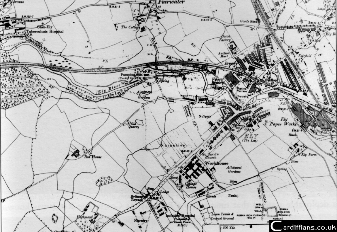
Source: OS
For hundreds of years Ely was a Hamlet with a small fishery and a corn mill. After the Norman Conquest of south-east Wales in the 1090s, Ely was given to the manor of Llandaff.
The Village Toll and Pumping Station
The residents lived in cottages around the Bridge and Mill Road. Some examples of the cottages can still be seen today.
In the mid 1760s, the Turnpike Trust was created by the Council of Cardiff. The trust would set up the equivalent of modern day toll booths across the town, including on Ely Bridge.
Soon, horse drawn mail-coaches were making their way through Ely on their way to Milford Haven.
The Dusty Forge pub (now a youth centre) was for a long time, a mail-coach stop. Ely Bridge has been renovated many times since the 1600s, with it last being reconstructed in 1911.
During 1849, a cholera epidemic broke out in Cardiff. In order to combat the threat, increased sanitation and pure water was required. The Cardiff Water Company purchased the corn mill and built a pumping station to draw water from the river.
Local Industries
© Matthew Witty
Though Ely was still regarded as ‘a small village in the parish of Llandaff’, the opening of Ely train station in 1850 helped to bring new employment to the area.
Most industries were based around the bridge, and among these were two breweries.
The Ely Brewery was established in 1855, and in 1895 Crosswell’s Brewery started trading - this later became the Rhymney Brewery.
In 1959 the two companies merged and seven years later, it was taken over by Whitbread’s. In 1982, the smell of hops vanished forever when the brewery was closed down.
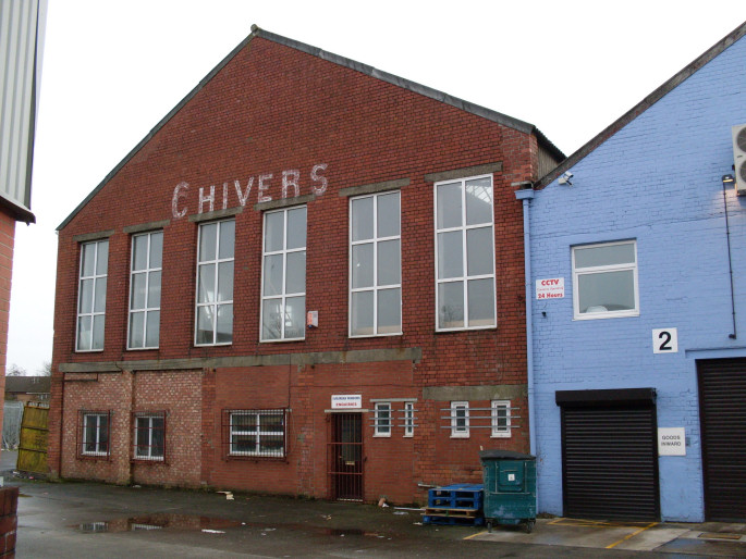
Not far from the breweries, Samuel Chivers had set up his food production factory in 1890. Famous for its vinegar, pickles and jam, Chivers’ was in operation until 1977 when it was sold off, and unfortunately closed down a few years later.
Ely Farm, an unassuming building near Trelai Park that was hundreds of years old, was a family home until its landlord, the Welsh Assembly Government, sold it off to redevelop the land in 2012.
Ely Paper Works
The Ely Paper Works, which opened in 1865, was sited south-east of the bridge and within 20 years it was the largest producer of newsprint in Britain.
Arjo Wiggins became the owners in 1990, and as the company switched to the manufacturing of carbonless (biodegradable) paper. Unfortunately, the company closed in 1999 due to falling demand, with home and office computers replacing the need for paper documents.
Housing Developments
In 1922, Ely became a suburb of Cardiff and, following the Town Council's purchase of Red House Farm and Green Farm, over 3,000 council houses were built within two years.
The entire estate north of Cowbridge Road was completed before World War Two with houses built to a high standard with relatively new electric lighting.
The quality of the properties was so impressive, that the company that built them (Bright and Addicott) was given contracts to build similar estates across the town. This explains why some houses in Grangetown are very similar in design. Houses at Ely were in great demand and first priority was given to families living in overcrowded conditions.
Western Cemetery and Culverhouse Cross
The Western Cemetery was opened in 1936, with a section dedicated to the Imperial War Graves Commission, for those who lost their lives in the two world wars. Simple, white headstones serve as a reminder of servicemen who died in two world wars.
Since 1945, Ely has been expanding quickly. During the 1970s, the construction of the Cardiff Southern Distributor Road had begun - with the Ely Link Road and Culverhouse Cross completed by the early 1980s. The A4232 as it was designated, then continued north past St Fagans, almost matching the route of the Barry Railway for a few miles, as it heads towards the M4 motorway.
During the 90s and early 2000s, Culverhouse Cross saw further massive commercial development take place, with the adding of the Copthorne Hotel, the HTV Television Studios (then ITV) and a busy retail park. Private housing developments sprang up in and around the Drope, and northern Ely.
In 2015 the ITV Wales studios were demolished to make way for a housing estate, as was Glan Ely High School during 2020-22 for the same reason. The next year, the last remaining original village pub - The Coach House on Station Terrace - was demolished after its final manager, Paul Cottle, passed away in 2020.
Significant areas of fields and woodland have now been built on, both in the east and west of the suburb, slowly encoroaching on the River Ely and Great Western Railway. This includes the redeveloped Ely Paper Mill site - almost complete by 2024 - although there is hope this will include a railway station.
As climate change affects the weather, and further developments take place with little thought about how the reduction in trees and fields will affect the land's ability to absorb all the extra rainfall Cardiff now receives, flood risks along the Ely River continue to increase year on year.

Source: Matthew Witty
PAGE UPDATE HISTORY
31 March 2024 (Content and coding updates)
01 December 2014 (Page updated)
July 2009 (Page Created)